Join us on Monday, February 3, 2020 at 8:00PM EST (0100z, February 4) for part 4 of the Bush League Backcountry Fly-In Series! Our friend Tracks gets the hosting duties this month. Tracks, thanks for planning the route and pulling the details together for this virtual flight! This month’s group flight finds us back up in British Columbia, Canada, winding through the valleys between Cache Creek and Squamish. The airports in Tracks’ plan are all paved, so you don’t necessarily need a bush plane. Here are the details…
- Everyone is welcomed! Whether you’re an expert or beginner with flying simulators, radio communications, or navigation, etc., you’re invited! We’re a friendly bunch and enjoy learning from each other.
- All of the scenery and recommended aircraft is based on X-Plane 11.41.
- The starting airport will be Cache Creek Airport (CAZ5). We’ll then head west and south, finally ending up at Squamish Airport (CYSE) located at the north end of Howe Sound.
- You can fly whatever aircraft you’d like. This month’s selection of airports are all paved, so almost any aircraft able to land and depart from a 3000 ft. runway will work.
- Most of the pilots enjoy navigating via pilotage, i.e. “looking out the window” and comparing it to the sectional chart. The Canadian sectional charts are available via a free account at www.fltplan.com.
- We encourage you to join the VATSIM network and use the CTAF frequency of 122.8 to announce positions. Several CSL files are available to correctly render other aircraft.
- We’ll also use the Downwindsim Discord voice channel during the flight for non-ATC related chit-chat.
Flight Plan and Scenery Links:
Cache Creek (CAZ5) ->
Lillooet (CYLI) ->(direct link to CYLI download)
Pemberton – (CYPS) ->
Squamish – (CYSE)
Tracks has conveniently shared a suggested flight plan that can be pasted into skyvector.com…
CAZ5 505318N1212440W 505301N1213036W 504801N1213658W 505351N1214731W 505138N1215234W 504540N1215009W 504450N1215340W 504621N1215525W 504359N1215558W CYLI 504006N1220038W 504334N1221336W 503955N1222247W 503036N1223028W 502723N1224124W 502116N1224356W 501815N1224409W 501712N1225147W 501029N1225226W 500812N1225746W 500529N1230034W 500322N1230720W 495415N1231051W CYSE
Scenery Notes:
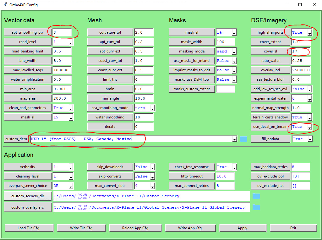
If you’re using X-Plane (v11.41 is the current at the time of this writing), we’d recommend, if your system can handle it, using Ortho4XP scenery. On this flight we’ll be flying in tiles +50-122, +50-123, +50-124, +49-123, +49-0124. We’d recommend these settings for these tiles in Canada for Ortho4XP and using this OSM data for +50-122 and this data for +50-123. Using Ortho4XP is NOT necessary, but does add to the realism.
For those hooligans out there (and you know who you are) looking for a little adventure… there are several options for getting from point A to point B… with a sand bar, beach or mountain plateau in between. We’d like to suggest you try to find BL20 Birkenhead Lake Airstrip and DL20 Duffey Lake Airstrip. These are NOT on the sectional, but the names should give you a hint. You’ll definitely want ortho scenery for these and a good helping of short-field skills. A big thanks to Melvin Leroy for his help with these!
Ask questions on the DownwindSim Discord bush-flying channel if you need any help. See ya Monday!