Mission:
The state of Wyoming is home to some interesting WWII era military and aviation history. For this month’s back country fly-in you will serve as a tour guide, transporting a group of history buffs to some gems hidden among the mountains of Western Wyoming. These tourists are especially excited about the possibility of visiting these sites in military aircraft specific to the time period, and are willing to pay extra to do so. Additional bottles of Laphroaig are being offered to any pilot who can provide a C-47 for the trip.
Background & Itinerary:
If you are going to lead this tour, you may as well know what you’re talking about.
National Museum of Miltary Vehicles: The small mountain town of Dubois is host to one of the world’s largest Military Vehicle Museums. We will plan to meet at Dubois Municipal (KDUB) and begin our adventure from there. To get a close up look at the NMMV, head Southeast along the Wind River for approximately 12 miles. The museum is located on the West side of the highway, right before you hit the East Fork. There are several spots for helicopters to land if your group is so inclined.
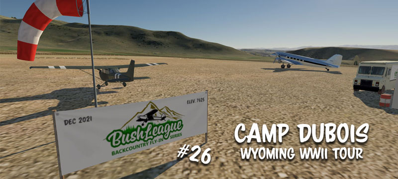
Camp Dubois: To continue to Camp Dubois, you will turn North along the East Fork of the Wind River for another dozen miles or so. One of 19 POW camps established in Wyoming toward the late stages of WWII, this was a timber camp, with prisoners cutting trees and constructing railroad ties. Due to the remote location, Camp Dubois has its own 1200 foot airstrip. It can accommodate most aircraft as long as you are careful and mind that altitude density. While you let the brakes cool down, be sure to take a little time and walk around what’s left of the original camp.
Camp Powell: We will then continue North to the agricultural POW Camp in Powell. The Absoraka mountains feature some high terrain challenges, with several peaks of more than 13,000ft in between. Be careful and patient in the climb out. If you can’t get that high, plan your route through either Bear Creek Pass, East Fork Pass, or Coal Chute Pass. They allow a safe travers at just over 11,000 ft.
While most have heard of the Heart Mountain Confinement Site, little is know about Camp Powell, which was located just a few miles East. Here, German and Austrian prisoners provided labor to assist local farmers during harvest season. The original camp site has now been overtaken by the town of Powell, so unfortunately there is nothing to show the tourists. We will conclude our tour by landing at Powell Municipal Airport (KPOY).
Amelia Earhart: Many are surprised to learn that the talented aviator absolutely loved the very mountains we will be traveling. If you can discover the Easter Eggs hidden here and there along the way, you will learn the location of two additional landing spots. One is a true blue, bush style, off-airport strip around 800 ft long. The other, a well maintained dirt strip that doubles as a very unique slice of history.
Bush League Basics:
- Everyone is welcome! Whether you’re an expert or beginner with flight simulators, radio communications, or navigation, etc., you’re invited! We’re a friendly bunch and enjoy learning from each other.
- Leave your GPS at home (or only for an emergency). That’s adds to the fun and challenge.
- We encourage you to join the VATSIM network and use the CTAF frequency of 122.8 to announce positions. We will not be in communication with ATC unless you plan to extend your flight into a controlled airspace.
- We’ll also use the Downwindsim Discord voice channel during the flight for non-ATC related chit-chat.
- As always, the main goal of these flights is to have fun, practice your navigation skills and good airmanship. We normally fly real time and real weather, but this event is a daytime only flight. Please adjust your time accordingly. As for weather, that’s up to you, but part of what makes flying in the mountains so much fun is navigating that high altitude wind and precipitation.
Ortho4XP and Scenery Installation Instructions:
Here is the link to the scenery needed for X-Plane pilots. Camp Dubois
It includes everything needed for the event. There are two aiports.osm.bz2 files you will need to place in the appropriate Ortho4XP>OSM_data folder. Don’t forget to recook tiles +43-110 and +44-109 afterward.
Pilots flying in MSFS will find the same landing areas modeled very well in the default, with the exception of the National Museum of Military Vehicles. Unfortunately, I do not have the scenery making skills to create the custom objects that contain this building or the well loved Easter Eggs. Instead, I have also included a folder in the scenery zip titled “Extra Hints” which will give you the same basic information those in X-Plane will have.That is, if they are able to find the clues.
IMPORTANT: This is the answer key! Do not download and view unless you must.
Flight Briefing:
Plan to gather in the DWS Group Voice channel (over on DownwindSim’s Discords) at 6pm MST for the briefing.